
Tuesday, February 28, 2006

google maps at night, sailor's delight?
A Georgia Tech PhD student has a site that displays the earth at night. He has used night-time satellite imagery from NASA and uses Google Maps to manage the maps. It looks really beautiful. Check it out here
Guess which is the darkest continent? :)
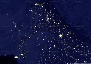
This image shows Pakistan and India, the bright lights at the bottom left are Karachi, and there are lights again all the way along the GT road that snakes through the country up-to Peshawar in the North, the other bright spot on the right appears to be Bombay
"The underlying 128 megapixel night imagery from NASA uses a map projection different from Google Maps'. The two are aligned near the NYC-Madrid-Tokyo axis only"
The creator of the site has a very good blog, too, check it out here
Subscribe to:
Posts (Atom)