Research showed that it was a genuine document drawn in 1513 by Piri Reis, a famous admiral of the Turkish fleet in the sixteenth century.
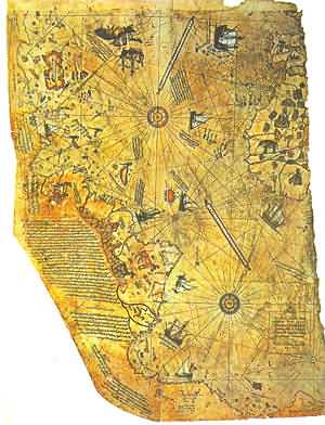
The Piri Reis map shows the western coast of Africa, the eastern coast of South America, and the northern coast of Antarctica. The northern coastline of Antarctica is perfectly detailed. The most puzzling however is not so much how Piri Reis managed to draw such an accurate map of the Antarctic region 300 years before it was discovered, but that the map shows the coastline under the ice. Geological evidence confirms that the latest date Queen Maud Land could have been charted in an ice-free state is 4000 BC.
link
1 comment:
Nice blog, see you at internet.
Regards from Spain
;-)
Post a Comment